团期与价格
同行价格信息仅对签约同业客户开放。
登录后查看同行价行程文档
英语行程
14 Days Ultimate Tibet Group Tour: Mount Kailash, Guge Kingdom & Hidden North
Day 1 · Arrival in Lhasa | Airport Pick-up and Hotel Check-in
Overview: Altitude: 3650m | Distance: 60km, about 1-1.5 hours’ drive
Attractions: Have a good rest, get used to the altitude
Activities: Arrive in Lhasa by yourself; pick-up service while in Lhasa
Accommodation: Comfortable
Tashi Delek! Welcome to Lhasa, the capital of the Tibet Autonomous Region! Upon arrival at Lhasa Gonggar International Airport or Lhasa Railway Station, our friendly Tibetan guide will greet you with a Hada (a traditional white silk scarf) and warm blessings. (Tip: Please let us know your mode of transportation and arrival time in advance.) After that, our guide and driver will escort you to your hotel in downtown Lhasa. (Tip: The airport is located about 60 km southeast of the city, 1-1.5 hours' drive.) After check-in, take the rest of the day to relax and acclimatize to Lhasa's high altitude (3,650 m). It's important to allow your body to adjust before beginning your exciting journey through Tibet. Helpful Reminders for Your First Day in Lhasa Take a good rest and stay calm. This is the best way to prevent altitude sickness. Avoid strenuous activity and you'd better not take a shower on the first night to prevent catching a cold. Do not drink alcohol. Instead, drink plenty of water, eat fruits, and avoid heavy meals. If you wish, you can prepare herbal or oxygen supplements such as Rhodiola, American ginseng lozenges, or Gaoyuan'an to help with adaptation. Always follow the advice of your local guide. If you feel unwell, inform your guide and seek medical attention promptly.
Day 2 · Lhasa City Tour | Potala Palace, Traditional Handicraft Center, Barkhor Street
Overview: Altitude: 3650m
Attractions: 3 Iconic Sites
Activities: Tourist Vehicle
Meals: Breakfast
Accommodation: Comfortable
Today, it is the time to explore Lhasa by visiting the world-famous Potala Palace, a World Heritage site and the picture behind the 50 RMB. And then, you will explore Lhasa by visiting Jokhang Temple, a world cultural heritage site renowned for its brilliant architecture, culture, art, and history. Finally, you can stroll through the famous Barkhor Street with locals and learn more about the daily kora life of Tibetans. This morning, you'll first explore Potala Palace. This is the most iconic landmark of Tibet and the former winter residence of the Dalai Lamas (1649-1959). After climbing 365 stone steps from the palace gate to the Red Palace, you'll reach the highest ancient palace in the world - standing proudly at 3,700 meters above sea level - and enjoy stunning panoramic view of Lhasa city. As you wander through the halls, chapels, and sacred shrines that honor past Dalai Lamas, you'll be captivated by the intricate murals, exquisite carvings, dazzling jeweled decorations, and the deep spiritual atmosphere that fills the air. Inside the Potala Palace, countless Tibetan pilgrims can be seen bowing and praying devoutly - for many, visiting this sacred site is the journey of a lifetime. Your guide will also share fascinating stories about King Songtsen Gampo, the 33rd ruler of Tibet, who originally built the Potala Palace in the 7th century to honor his marriage to Princess Wencheng of the Tang Dynasty. Potala Palace Visiting Tips: All visitors must enter as part of a guided group and can stay inside for a maximum of one hour. Tickets are issued under a real-name reservation system. A valid ID or passport is required, and once reserved, rebooking is not allowed within 7 days. Entry times are assigned randomly by the Potala Palace Administration, and it's not possible to choose your visiting hour. During peak season, your travel group may be split into smaller sub-groups with different visiting times or guides. Photography is strictly prohibited inside the palace. We will take you to fully immerse yourself in experiencing traditional Tibetan handcraft Center, including making Tibetan incense, woodblock printing and learning about the Tibetan language. While learning about how the refreshing Tibetan incense is made, you can also participate in making it with your own hands, which is of quite different significance from the purchased Tibetan incense. Knowledgeable teachers will introduce to you the origin of the Tibetan language and help you write Tibetan blessings or your own Tibetan name. Meanwhile, you can also experience the traditional woodblock printing. The incense, printed words and Tibetan calligraphy can all be taken home as souvenirs. After the visit, step outside to Barkhor Street, once the traditional kora (pilgrimage circuit) around the temple. Today, it's a lively place filled with the scent of incense and the sounds of chanting pilgrims. You can sip yak butter tea at a teahouse, dress in Tibetan attire for photos, or shop for unique handicrafts and souvenirs from Tibet, Nepal, and India. After the tour, be escorted back to your hotel in Lhasa.
Day 3 · Lhasa - Yamdrok Lake - Karola Glacier - Shigatse
Overview: Altitude: 3650~4797~3845 meters | Distance: 370km, about 7 hours’ drive
Attractions: 2 Sites
Activities: Tourist Vehicle
Meals: Breakfast
Accommodation: Comfortable
Today, you'll embark on a scenic drive from Lhasa to Shigatse, Tibet's second-largest city. The journey covers around 370 kilometers and takes 7 hours' drive, with stops to admire two of Tibet's most spectacular natural wonders - Yamdrok Lake and Karola Glacier. In the morning, after about 2-3 hours of driving (110 km), get your camera ready as you approach Kampala Pass (4,797 m). Here, you'll be rewarded with a breathtaking panoramic view of Yamdrok Lake, a turquoise ribbon shimmering among snow-capped mountains. Known as one of Tibet's four sacred lakes (along with Lhamo Latso, Manasarovar, and Namtso), Yamdrok is believed to hold spiritual power - helping Tibetans locate the reincarnated soul of the Dalai Lama. You'll also see locals offering photo opportunities with Tibetan mastiffs, yaks, or goats dressed in traditional ornaments. In the afternoon, continue driving for about 1.5 hours (87 km) to reach the stunning Karola Glacier (5,012 m) - one of Tibet's three major continental glaciers and a filming site of the movie Red Valley (Hong He Gu). Backed by Naiqin Kangsang Peak (7,191 m), the glacier gleams like a frozen waterfall cascading right beside the highway. You can enjoy the view from your vehicle or take a short, easy walk to the glacier's base. Across the road, admire the majestic snow-capped Mount Kalurong - another highlight of this alpine wonderland. Tips for visiting Karola Glacier: The alitude here is about 5,012 meters, so move slowly and avoid overexertion. The public toilets are very basic -be prepared. Some locals may charge a small fee for taking photos with them or their animals -always confirm before photographing. Afterward, drive about 3.5 hours (170 km) through Gyantse, along the wide Nianchu River Valley, passing through scenic Tibetan villages, vast barley fields, and golden rapeseed flower fields (in summer). Upon arrival in Shigatse (altitude: 3845 meters), check into your hotel and rest well. Warm Reminder: For foreign and Taiwan travelers, registration at the Shigatse Entry & Exit Administration Office is required. Your guide will assist with the process and may adjust the schedule accordingly - please follow their instructions and cooperate as needed.
Day 4 · Shigatse - Sangsang Town (Sangsang Grassland) - Saga Town
Overview: Altitude: 3845~4567~4640 meters | Distance: 450km, about 8 hours’ drive
Attractions: 1 site
Activities: Coach
Meals: Breakfast
Accommodation: Comfortable
After breakfast, your group will leave Shigatse - the cultural heart of western Tibet - and set out on a long but scenic drive westward to Saga Town (about 450 km, about 8 hours). As you leave the bustling city behind, your journey heads west along the Nyanchu River Valley, historically known as the Breadbasket of Tibet. Along the way, you'll pass through vast farmlands where barley and rapeseed flowers sway gently in the breeze, reflecting Shigatse's long-standing reputation as the region's granary. Gradually, the fertile valley opens into the wide, wild beauty of the western plateau. On the way, make a stop in Sangsang Town to visit the stunning Sangsang Grassland (altitude: 4,567 meters). Here, you will encounter a vast green sea in summer. The fields bloom with purple pedicularis and yellow Galsang flowers, while herds of yaks and Tibetan sheep graze freely like stars scattered across a green carpet. Overhead, eagles circle gracefully, and the wind carries the scent of wild grass. This pure, untamed life of the Tibetan plateau will simply amaze you. After the visit, your group will continue the drive, heading westward to Saga Town. Out of your window, you will see the distinctive landscape of alpine meadows and arid grasslands. You will also have the opportunity to gaze upon the northern peaks of the Himalayan mountain range in the distance. You will arrive in Saga Town (altitude: 4640 meters) in the late afternoon and check into your hotel.
Day 5 · Saga Town - Zhongba Colorful Desert - Lake Gongzhucuo - Lake Manasarovar - Darchen Town
Overview: Altitude: 4640~4586~4670 meters | Distance: 550km, about 9 hours’ drive
Attractions: 3 Sites
Activities: Tourist Vehicle
Meals: Breakfast
Accommodation: Comfortable
After breakfast, your group will set out along the G219 Highway. Enjoy the drivie from Saga Town toward Darchen, the gateway to Mount Kailash. It is never boring on road, changing landscapes, Tibetan villages and farmlands, holy mountains and lakes. As you leave Saga behind, the road gradually ascends along the northern foothills of the Himalayas, where the landscape unfolds in layers of color and texture. In Zhongba, small Tibetan villages appear like splashes of color against the edge of the desert, fluttering prayer flags dancing in the wind. You'll pass through a vast dune belt (Zhongba Colorful Desert) - its sands tinted red, yellow, and white by rich minerals. Under the bright plateau sun, the dunes shimmer like silk against the distant backdrop of snowcapped mountains and winding rivers - a true visual feast. Continuing westward, you'll cross the shores of Lake Gongzhucuo, whose deep sapphire waters mirror the majestic Gangdise Mountains beyond. The scene feels both tranquil and otherworldly. Soon after, you'll reach one of the most sacred and breathtaking moments of your Tibetan journey: the sudden appearance of Lake Manasarovar and the legendary Mount Kailash. Rising high above the surrounding peaks, Mount Kailash's perfectly symmetrical snow-covered cone forms a divine tableau with the shimmering lake below. Revered by Buddhism, Hinduism, Bon, and Jainism, Lake Manasarovar is believed to be the source of four of Asia's great rivers - the Yarlung Tsangpo, Indus, Sutlej, and Karnali. Along the lakeshore, you may see pilgrims walking clockwise around the holy lake, spinning prayer wheels and chanting softly as they etch their devotion into every Mani stone along the way. By late afternoon, arrive at Darchen Town (altitude: 4670 meters). This is the base and starting point for the Mount Kailash Kora (pilgrimage circuit). Check into your hotel and rest well in preparation for the next spirtual circuit.
Day 6 · Mt. Kailash Trek Day One: Darchen - Tarboche - Driapuk Monastery
Overview: 6km Sightseeing Bus + 14km Trekking, 7-8 Hours
Attractions: 2 sites
Activities: Trekking
Accommodation: Comfortable
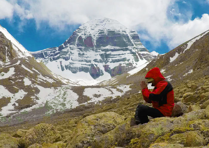
Starting Point: Darchen Town (Elevation: 4,675 m) Ending Point: Dira-Puk Monastery (Elevation: 5,100 m) Total Distance: Approx. 20 km (12.4 miles) Distance Breakdown: Scenic Bus Ride: Approx. 6 km to the Prayer Flag Pole (Darbochhe) Trekking Distance: Approx. 14 km (8.7 miles) Trekking Duration: Approx. 7-8 hours Difficulty Level: Challenging (due to altitude)Mount Kailash, is a towering peak that rises to 6,638 meters and dominates the landscape of Western Tibet. Revered by four major religions - Tibetan Buddhism, Hinduism, Bon, and Jainism, this holy mountain is considered the spiritual center of the world. In Tibetan Buddhism, it is believed to be the abode of Demchok, the deity symbolizing supreme bliss. Each year, countless pilgrims make the arduous journey here to walk the 52-kilometer kora (circumambulation) around the sacred mountain, a deeply spiritual act believed to cleanse one's sins and bring enlightenment. Day One Trek: Darchen - Tarboche - Dira-puk Monastery This morning, your group will take a short sightseeing bus ride from Darchen Town to Tarboche (Prayer Flag Square, 6km from the town). This is the official starting point of the kora and one of the most sacred ritual sites in Tibet. Every year during the Saga Dawa Festival ("Fourth Month" in the Tibetan calendar), hundreds of pilgrims gather here to raise the towering flagpole adorned with prayer flags, celebrating the birth, enlightenment, and death of Buddha Sakyamuni. Now, begin your first day of trekking, following the Lha Chu River valley westward. The route is graced by blue skies, snow-capped peaks, and slopes dotted with mani stones engraved with sacred mantras. Along the way, you'll see Tibetan pilgrims performing prostrations as they slowly make their way around the mountain - a moving testament to faith and devotion. This section is both physically demanding and spiritually rewarding, offering magnificent views of Mount Kailash's western and northern faces. As you venture deeper into the valley, the north face of Mount Kailash gradually reveals itself in full grandeur, an awe-inspiring sight that few places on Earth can rival. After trekking about 14 kilometers, you'll arrive at Dira-puk Monastery, your destination for the day. This monastery, belonging to the Nyingma sect of Tibetan Buddhism, sits directly opposite the north face of Mount Kailash, providing an unparalleled view of the sacred mountain. You will spend the night in a local guesthouse near Dira-puk Monastery. Travel Notes: Local Tibetans around Mount Kailash offer optional services such as horse or yak rides, and luggage transport by yaks or porters (not included in the tour price). During the kora, accommodation is very basic, typically in shared guesthouses or tents at Dira-puk and Dzultripuk, with limited facilities (multi-bed rooms, shared toilets, one bed per traveler).
Day 7 · Mt. Kailash Trek Day Two: Driapuk Monastery - Drolma-la Pass - Dzultripuk Monastery
Overview: 20km Trekking, 10-11 Hours
Attractions: 3 sites
Activities: trekking
Accommodation: Zutul-Puk Monastery
Starting Point: Dira-Puk Monastery / Gangja (Elevation: 5,100 m) Highest Point: Drolma La Pass (Elevation: 5,650 m) Ending Point: Dzultripuk Monastery (Elevation: 4,880 m) Trekking Distance: Approx. 20 km (12.4 miles) Trekking Duration: 10–11 hours Difficulty Level: Challenging Start your trekking early in this morning. Today marks the most challenging and spiritually significant day of your Mount Kailash Kora. The trail leads you on a strenuous ascent of more than 550 meters to the sacred Drolma-la Pass (5,650m) - the highest point of the entire circuit. This demanding section tests both body and spirit. According to Tibetan Buddhist belief, successfully crossing the Drolma-la Pass symbolizes the purification of one's sins from a lifetime. Despite the thin air and rugged terrain, pilgrims consider this moment a deep act of faith and renewal. At the summit, you'll be greeted by a breathtaking sight - thousands of colorful prayer flags fluttering in the wind, blanketing the pass in a sea of sacred colors. Many pilgrims pause here to rest, pray, and add their own mani stones to the growing piles of devotion. The descent that follows is steep and rocky, leading into the Lhachu Valley. Along the way lies the shimmering Gauri Kund, a glacial lake revered in Hinduism as the bathing place of Parvati, the consort of Lord Shiva. Its jade-like waters glisten serenely beneath the towering peaks. After a short rest, continue your trek for another four hours along the riverbank until you reach Dzultripuk Monastery (4,810m), known as the “Miracle Cave of Milarepa.” This sacred monastery, belonging to the Sakya sect, holds ancient murals, scriptures, and legends of the great yogi Milarepa. Spend the evening resting at the guesthouse near Zutul-Puk. Have a good rest and prepare for the final leg of the Kora tomorrow.
Day 8 · Dzultripuk Monastery - Darchen Town (Trekking 6.6km + Sightseeing Bus 4km) - Drive to Zanda
Overview: Altitude: 4675 meters | Distance: 230km, about 4.5 hours’ drive
Attractions: 1 site
Activities: trekking, tourist vehicle
Meals: Breakfast
Accommodation: Zanda
Starting Point: Dzultripuk Monastery (Elevation: 4,880 m) Trekking End: Zongdui (Elevation: 4,680 m) Final Destination: Darchen Town (Elevation: 4,675 m) Total Distance: 10.6 km (approx. 6.6 miles) Distance Breakdown: Trekking: Approx. 6.6 km (4.1 miles) Shuttle Ride: Approx. 4 km (2.5 miles) Trekking Duration: 2-3 hours Difficulty Level: Easy Today marks the final leg of your Mount Kailash Kora - a day of completion and quiet reflection. After breakfast, you will leave Dzultripuk Monastery, and begin a gentle descent as the altitude gradually lowers. The stark white of the high mountain snows slowly gives way to vibrant greens of grass and shrubs, signaling your return to the realm of life and movement. Along the trail, you may spot small animals (like groundhogs) darting among the bushes, while countless mani stones - prayer-carved rocks stacked in colorful mounds - line your path like silent guardians, echoing the devotion of generations of pilgrims. The air feels lighter, and each step brings a sense of relief and fulfillment. After walking the final 6.6 kilometers, you'll reach Zongdui, where your Mount Kailash circuit officially comes to an end. Here, you can board the eco-sightseeing bus that will take you back to Darchen Town. By midday, you'll arrive in Darchen - tired yet deeply content - having completed one of the world's most sacred pilgrimages. Yes, you did it! Great job! In the afternoon, your journey continues toward Zanda, located in the heart of Ngari Prefecture. 230 kilometers, roughly 4.5 hours. As you leave Darchen behind, the rugged landscapes unfold into a mesmerizing panorama of eroded canyons, barren cliffs, and river valleys - a stark yet captivating portrait of Tibet's remote western frontier. Upon arrival in Zanda County (altitude: 4500 meters), you'll find yourself surrounded by an otherworldly terrain carved by wind and water over centuries. This region is not only a geological wonder but also a cultural treasure, home to the legendary Guge Kingdom ruins and the ancient Tholing Monastery, both offering deep insight into Tibet's forgotten civilizations. Stay overnight in Zanda.
Day 9 · Zanda - Guge Kingdom - Zanda Earth Forest - Xiayigou Earth Forest - Shiquanhe Town
Overview: Altitude: 4500~4255 meters | Distance: 280km, about 5 hours’ drive
Attractions: 3 Sites
Activities: Tourist Vehicle
Meals: Breakfast
Accommodation: Shiquanhe Town
Today, your group will first enjoy Zanda County, delving into both its ancient history and dramatic landscapes. Begin with a fascinating visit to the Ruins of the Guge Kingdom, one of Tibet's most mysterious archaeological sites. Flourishing between the 10th and 17th centuries, Guge was once a powerful kingdom that played a vital role in spreading Buddhism across western Tibet. The site features remarkable frescoes, sculptures, and carvings that vividly depict Buddhist teachings, royal life, and historical events. As you explore, you'll visit the Red Palace, once a major religious center with temples and monks' quarters, and the White Palace, the royal residence of the Guge kings. The blend of Tibetan, Indian, and Chinese architectural influences is evident in the intricate murals and carvings that still adorn the walls. From the top of the ruins, enjoy a sweeping panoramic view of the entire valley - a breathtaking reminder of the kingdom's former glory. Afterward, continue about 20 kilometers to the awe-inspiring Zanda Earth Forest, a geological masterpiece formed by centuries of wind and water erosion. Stretching for over five kilometers along the Elephant Spring River, this surreal landscape of natural sculptures resembles warriors, galloping horses, and meditating monks. The play of light and shadow across the ridges creates endless photo opportunities. Later, drive another 77 kilometers to the Xiayigou Earth Forest, where layers of soft red and ochre rock glow under the deep blue sky. Take a short hike down into the valley to observe the unique formations up close and capture stunning photos. After the tour, you will be transferred to your next destination - Shiquanhe Town (altitude 4,255m). This is the capital of Ngari Prefecture, where you'll check in and rest for the night.
Day 10 · Shiquanhe Town - Geji Town - Nyer Tso - Yanhu Town - Pero Tsetso Viewpoint - Wuma Tso - Gaize Town
Overview: Altitude: 4255~4500~4425 meters | Distance: 500km, about 6-7 hours’ drive
Attractions: 5 Sites
Activities: Tourist Vehicle
Meals: Breakfast
Accommodation: Gaize Town
After breakfast, bid farewell to Shiquanhe Town as your journey continues east toward Geji Town, tracing one of the most scenic routes in Northern Tibet. The day's drive is not just a transfer - it's a visual symphony of shifting landscapes and timeless tranquility. Leaving the Shiquanhe Basin, the road winds through lush red willow wetlands and scattered oases, where flashes of green bring life to the plateau. Gradually, the scenery transforms into the stark grandeur of the expansive Tibetan high plains, where sky and earth seem to merge in endless silence. En route, pause at the shimmering Nyer Tso Lake, a saltwater lake edged with brilliant white salt crystals that sparkle like snow under the sun. Here, you'll feel the quiet majesty of the Tibetan wilderness - its air so pure and its solitude so vast that it feels almost sacred. Continuing the drive, you'll reach Yanhu Town, a place where the rhythm of traditional Tibetan life still beats strong. Look out for nomadic tents dotting the horizon, with yaks and sheep grazing freely across the open grasslands. Once a thriving hub of the ancient salt trade, Yanhu's legacy dates back over a thousand years. Traders once loaded salt onto sheep and yaks along the famous “Salt Sheep Trail,” journeying across the Himalayas to barter for goods in Shigatse, Nepal, and India. Further along, stop at the Pero Tsetso Viewpoint, where the lake below shifts from turquoise to emerald depending on the light. From this vantage point, you can often spot Tibetan wild asses and antelopes grazing along the lakeshore - a perfect chance for wildlife observation and photography. Before reaching your destination, you'll pass by the serene Wuma Tso Lake, its calm waters alive with graceful waterbirds gliding across the surface. By late afternoon, arrive in Gaize Town (altitude: 4425 meters). Have a good rest tonight.
Day 11 · Gaize Town - Tong Tso - Tangra Yumco - Wenbu Nancun Village
Overview: Altitude: 4425~4396~4530~4700 meters | Distance: 450km, about 6-7 hours’ drive
Attractions: 3 Sites
Activities: Tourist Vehicle
Meals: Breakfast
Accommodation: Wenbu Nancun Village
Today, after breakfast, your journey continues across the boundless expanse of Northern Tibet, a land where nature unfolds in its purest and most awe-inspiring form. As you travel deeper into this remote region, the scenery shifts dramatically - the vast Qiangtang Grassland stretches endlessly before you, merging with the rugged Gobi landscape. Herds of yaks and sheep graze freely under the open sky, while distant snow-capped peaks shimmer like silver ribbons along the horizon. Your first stop today is Tong Tso Lake, whose name in Tibetan means “Desolate Lake.” Despite its name, the lake's stillness exudes a unique charm - its tranquil waters mirroring the solitude and serenity of the high plateau. As you continue your drive, the mountain ranges rise higher and more majestic, forming a breathtaking panorama of snow and sky. The road toward Tangra Yumco (Dangra Yongcuo) is one of the most spectacular in Northern Tibet. In this remote land, it's not uncommon to encounter herds of Tibetan antelopes and wild donkeys galloping alongside the road - a truly unforgettable sight that brings the wilderness to life. Gradually, the magnificent Tangra Yumco Lake unfolds before your eyes. Known as the most sacred lake of the Bon religion, Tangra Yumco is often described as the “soul of this route.” The lake stretches more than 70 kilometers from north to south, like a blue silk ribbon laid across the heart of Ngari. Depending on the sunlight, its waters shift through shades of deep and light blue, reflecting the snow-capped peaks of the Dargo Mountains in serene perfection. Take your time to breathe in the quiet beauty and take good photos. After the sightseeing, be transferred to the nearby Wenbu Nancun Village (altitude: 4700 meters) for your overnight stay. The village is nestled between the mountains and the lakeshore, where earth-toned houses blend harmoniously with the azure lake and red-hued cliffs. Enjoy a quiet night by the lake and have a good sleep.
Day 12 · Wenbu Nancun - Tangqung Co Lake - Tree of the Earth - Selin Co Lake - Bangkog Co Lake - Baingoin County
Overview: Altitude: 4700~4530~4700 meters | Distance: 680km, about 10-11 hours’ drive
Attractions: 4 Sites
Activities: Tourist Vehicle
Meals: Breakfast
Accommodation: Baingoin County
After breakfast, begin your day in Wenbu Nancun Village, where the serene beauty of the plateau unfolds before you once more. Just north of the village lies Tangqung Co Lake, known as the “sister lake” of Tangra Yumco. Here, you'll witness a rare natural wonder - the Two-Colored Lake Phenomenon - where the water shifts magically between shades of emerald green and sapphire blue, depending on the angle of the sunlight. Along the lakeshore, herds of yaks graze peacefully, while Tibetan houses and fluttering prayer flags create a picture of harmony between humans and nature. Continue your drive to one of Northern Tibet's geological marvels, the “Tree of the Earth.” At first glance, the ground may appear ordinary. But from an aerial view, ancient erosion patterns form the stunning image of a colossal tree, complete with roots, trunk, and branching limbs. This extraordinary sight is a masterpiece sculpted by time, wind, and flowing water, perfectly representing the raw, desolate beauty of the Ngari highlands. Following the route eastward, you'll arrive at Selin Co Lake (Serling Tso) - the second-largest lake in Tibet and one of its most mystical. Often called the “Demon Lake”, local legend tells that a fierce spirit once dwelled here until subdued by the great Guru Padmasambhava. Today, the lake lies within the Qiangtang National Nature Reserve, a vast sanctuary of wildlife. Its immense surface stretches like an inland sea, glimmering under the highland sun, while black-necked cranes, Tibetan antelopes, and gazelles can often be seen along its shores. Your journey continues to Bangkog Co Lake, part of the same lake system as Selin Co. Sitting at an elevation of around 4,693 meters, this saltwater lake mirrors the sky in soft hues of light blue and pale green, blending seamlessly with the surrounding grasslands to create an ethereal landscape. By late afternoon, you'll arrive in Baingoin Town (altitude: 4700 meters). Enjoy a warm and comfortable stay here.
Day 13 · Baingoin County - Namsto Lake (Tashi Dor Peninsula) - Nagenla Pass - Lhasa
Overview: Altitude: 4700~4530~4700 meters | Distance: 400km, about 6-7 hours’ drive
Attractions: 1 Site
Activities: Tourist Vehicle
Meals: Breakfast
Accommodation: Lhasa
After breakfast, your whole group will continue your trip across the vast and windswept grasslands of Northern Tibet. The road keep remain around 4700 meters. The along scenery shows the essence of Tibet's nomadic life. Endless meadows stretching toward the horizon, herds of black-and-white yaks grazing freely, and the occasional eagle gliding across the brilliant sky, all set against a backdrop of distant snow-capped peaks. The drive from Baingoin county to Namtso Lake covers about 200 km (3 to 3.5 hours). As you enter the Namtso National Scenic Area, the deep-blue waters of this sacred lake unfold before you, reflecting the majestic Nyenchen Tanglha Mountain Range. Colorful prayer flags flutter in the crisp wind, and traditional Tibetan houses dot the lakeshore, very impressive. At an elevation of 4,718 meters, Namtso Lake - meaning “Heavenly Lake” in Tibetan - is one of the three great sacred lakes of Tibet and the highest saltwater lake in China. It is revered in Tibetan Buddhism as the spiritual dwelling of a goddess. Pilgrims often visit to pray, meditate, and walk the kora around its shores. The lake's ever-changing hues, shifting from turquoise to deep sapphire under the sunlight, make it a paradise for photography and contemplation alike. You'll explore the scenic Tashi Dor Peninsula, the heart of the Namtso area. This limestone peninsula features unique karst formations, with stone pillars and natural arches rising above the water. The famous “Welcoming Rock” (or Couple Stone) stands with open “arms” as if greeting travelers, while the Lotus Cave and its natural stupa add a mystical touch. On the peninsula stands Tashi Dor Monastery, shrouded in incense smoke and surrounded by colorful prayer flags that dance in the wind, creating a vivid living thangka of devotion and nature. After your visit, begin the drive to Lhasa. Crossing the Nagenla Pass at 5,190 meters, you'll be rewarded with a panoramic view of Namtso Lake shimmering beneath you - where the lake and sky merge into one boundless expanse. By late afternoon, you'll arrive back in Lhasa. This marks the end of your circle tour.
Day 14 · Lhasa Departure | Hotel Check-out & Transfer Service
Overview: Altitude: 3650m | Distance: 60km, about 1-1.5 hours’ drive
Attractions: Transfer to the airport or train station for departure
Activities: Tourist Vehicle
Meals: Breakfast
After breakfast, it's time to say goodbye to the holy city of Lhasa. Your guide and driver will escort you to Lhasa Gonggar Airport or Lhasa Railway Station. Take your flight or train to next destination or go home. Travel Tips: The drive from downtown Lhasa to the airport takes about 1 hour, so we recommend booking flights departing after 10:00 AM. Please share your flight or train schedule with us in advance to ensure a smooth transfer. Kindly provide accurate flight or train booking details so that we can arrange the group's complimentary shared transfer efficiently. Thank you for choosing Asia Odyssey Travel for Tibet Group Tour. We hope to see you on your next journey!
中文行程
14天西藏经典拼团游:冈仁波齐、古格王国与藏北秘境
第1天 · 抵达拉萨:接机与酒店入住
扎西德勒!欢迎来到西藏自治区首府拉萨!抵达拉萨贡嘎国际机场或拉萨火车站后,我们友好的藏族导游将为您献上哈达(传统白色丝巾)并致以温暖的祝福。(提示:请提前告知我们您的交通方式和抵达时间。) 之后,我们的导游和司机将送您前往拉萨市中心的酒店。(提示:机场位于市区东南约60公里处,车程约1-1.5小时。) 办理入住后,利用当天剩余时间放松休息,适应拉萨的高海拔(3650米)。在开始激动人心的西藏之旅前,让身体适应非常重要。 拉萨首日实用提醒 好好休息,保持平静。这是预防高原反应的最佳方式。 避免剧烈活动,第一晚最好不要洗澡,以防感冒。 不要饮酒。相反,多喝水,吃水果,避免油腻大餐。 如果您愿意,可以准备草药或氧气补充剂,如红景天、西洋参含片或高原安,以帮助适应。 始终遵循当地导游的建议。如果您感到不适,请告知导游并及时就医。 概述:海拔:3650米 | 距离:60公里,约1-1.5小时车程 景点:好好休息,适应海拔 交通与活动:自行抵达拉萨;在拉萨期间提供接机/接站服务 住宿:舒适
第2天 · 拉萨城市游:布达拉宫、传统手工艺中心、八廓街
今天,我们将游览世界闻名的布达拉宫,这是一处世界遗产,也是50元人民币背面的图案。随后,您将继续探索拉萨,参观大昭寺,这处世界文化遗产以其辉煌的建筑、文化、艺术和历史而闻名。最后,您可以与当地人一起漫步在著名的八廓街上,进一步了解藏族人的日常转经生活。 今天上午,您将首先参观布达拉宫。这是西藏最具标志性的地标,也是达赖喇嘛的冬宫所在地(1649-1959年)。 从宫门攀登365级石阶到达红宫后,您将抵达世界上海拔最高的古代宫殿——傲然屹立于海拔3700米处——并欣赏拉萨市的壮丽全景。 当您漫步于殿堂、佛龛和供奉历代达赖喇嘛的神圣祭坛之间时,您会被精美的壁画、精致的雕刻、耀眼的珠宝装饰以及弥漫在空气中的浓厚宗教氛围所吸引。在布达拉宫内,可以看到无数藏族信徒虔诚地叩拜祈祷——对许多人来说,参观这处圣地是一生一次的旅程。 您的导游还将分享关于西藏第33代赞普松赞干布的精彩故事,他最初在7世纪建造布达拉宫,以纪念他与唐朝文成公主的联姻。 布达拉宫参观提示: 所有游客必须作为导游团的一部分进入,且最多只能在宫内停留一小时。 门票实行实名制预约。需提供有效身份证件或护照,且预约后7天内不得重新预约。 入场时间由布达拉宫管理处随机分配,无法自行选择参观时间。 旺季期间,您的旅行团可能会被分成更小的子团,有不同的参观时间或导游。 宫内严禁拍照。 我们将带您完全沉浸在传统藏族手工艺中心的体验中,包括制作藏香、木版印刷以及了解藏语。在了解清新的藏香是如何制作的同时,您还可以亲手参与制作,这与购买藏香有着截然不同的意义。知识渊博的老师将向您介绍藏语的起源,并帮助您书写藏文祝福语或您自己的藏文名字。同时,您还可以体验传统的木版印刷。藏香、印刷文字和藏文书法都可以作为纪念品带回家。 参观结束后,走出寺庙,来到八廓街,这里曾是环绕寺庙的传统转经道。如今,这里是一个热闹的地方,弥漫着香火的气息,回荡着朝圣者的诵经声。您可以在茶馆里品尝酥油茶,穿上藏族服饰拍照,或购买来自西藏、尼泊尔和印度的独特手工艺品和纪念品。 游览结束后,送您返回拉萨的酒店。 概述:海拔:3650米 景点:3个标志性景点 交通与活动:旅游车 用餐:早餐 住宿:舒适
第3天 · 拉萨至羊卓雍措、卡若拉冰川、日喀则
今天,您将从拉萨驱车前往西藏第二大城市日喀则,沿途欣赏风景。全程约370公里,车程约7小时,途中会停留观赏西藏最壮观的两大自然景观——羊卓雍措和卡若拉冰川。 上午出发,行驶约2至3小时(110公里)后,准备好相机,因为您即将抵达岗巴拉山口(海拔4,797米)。在这里,您可以欣赏到羊卓雍措令人惊叹的全景,它宛如一条碧绿的丝带在雪山间闪耀。羊卓雍措是西藏四大圣湖之一(另外三座为拉姆拉措、玛旁雍措和纳木措),被认为具有精神力量——能帮助藏人寻找达赖喇嘛的转世灵童。您还会看到当地人与藏獒、牦牛或穿着传统饰品的山羊合影,供游客拍照。 下午继续驱车约1.5小时(87公里),抵达令人惊叹的卡若拉冰川(海拔5,012米)——西藏三大大陆型冰川之一,也是电影《红河谷》的拍摄地。冰川背靠乃钦康桑峰(海拔7,191米),像一条冻结的瀑布在公路旁闪耀。您可以在车内欣赏美景,也可以轻松步行一小段到冰川脚下。公路对面是雄伟的卡鲁雪峰,是这片高山仙境中的另一大亮点。 参观卡若拉冰川的提示: 这里海拔约5,012米,请放慢行动,避免过度劳累。 公共厕所非常简陋,请做好准备。 有些当地人可能会对与他们或他们的动物合影收取少量费用,拍照前请务必确认。 之后,驱车约3.5小时(170公里),途经江孜,沿着宽阔的年楚河谷行驶,穿过风景如画的藏族村庄、广阔的青稞田和金色的油菜花田(夏季)。抵达日喀则(海拔:3845米)后,入住酒店,好好休息。 温馨提示: 外国和台湾游客需要在日喀则出入境管理办公室进行登记。您的导游将协助办理,并可能相应调整行程,请遵循导游的指示并配合。 概述:海拔:3650~4797~3845米,距离:370公里,车程约7小时 景点:2个景点 交通与活动:旅游车 用餐:早餐 住宿:舒适
第4天 · 日喀则至桑桑镇(桑桑草原)至萨嘎镇
早餐后,团队将离开日喀则——西藏西部的文化中心——向西前往萨嘎镇,开始一段漫长但风景优美的车程(约450公里,约8小时)。 离开繁华的城市后,旅程将沿着年楚河谷向西行进,这里历史上被称为西藏的粮仓。沿途会经过广袤的农田,青稞和油菜花在微风中轻轻摇曳,印证了日喀则作为该地区粮仓的悠久声誉。 渐渐地,肥沃的山谷展开为西部高原辽阔而原始的壮美景色。途中会在桑桑镇停留,参观令人惊叹的桑桑草原(海拔4567米)。夏季在这里会看到一片广阔的绿色海洋。田野上盛开着紫色的马先蒿和黄色的格桑花,成群的牦牛和藏羊自由地吃草,犹如散落在绿色地毯上的星星。头顶有鹰优雅地盘旋,风中带着野草的气息。这纯净、未驯服的西藏高原生活将令您惊叹不已。 参观结束后,团队将继续驱车向西前往萨嘎镇。车窗外会看到高山草甸和干旱草原的独特景观。还有机会远眺喜马拉雅山脉北部的山峰。 傍晚时分抵达萨嘎镇(海拔4640米),并入住酒店。 概述:海拔:3845~4567~4640米 | 距离:450公里,约8小时车程 景点:1个景点 交通与活动:旅游大巴 用餐:早餐 住宿:舒适
第5天 · 萨嘎镇至塔尔钦镇:仲巴彩色沙漠、公珠错与玛旁雍错
早餐后,团队将沿G219国道出发,从萨嘎镇前往塔尔钦。塔尔钦是通往冈仁波齐的门户。一路上风景不断变化,有藏族村落、农田、神山和圣湖,车程不会枯燥。 离开萨嘎后,道路沿喜马拉雅山脉北麓逐渐攀升,沿途景色在色彩和质感上层层展开。在仲巴一带,小型藏族村落像点缀在沙漠边缘的色彩,经幡在风中飘动。您将穿过广阔的沙丘带,即仲巴彩色沙漠。这里的沙粒因富含矿物质而呈现红色、黄色和白色。在高原明亮的阳光下,沙丘如丝绸般闪烁,远处是雪山和蜿蜒的河流,构成一场视觉享受。 继续向西,您将经过公珠错湖畔。湖水呈深蓝宝石色,映照着远处雄伟的冈底斯山脉。景色宁静而独特。 不久之后,您将迎来西藏之旅中最神圣、最令人感叹的时刻之一:玛旁雍错和传奇的冈仁波齐突然出现在眼前。冈仁波齐高耸于周围山峰之上,对称的雪峰与下方波光粼粼的湖水形成神圣画面。玛旁雍错受到佛教、印度教、苯教和耆那教尊崇,被认为是亚洲四大河流——雅鲁藏布江、印度河、萨特莱杰河和卡纳利河——的发源地。在湖畔,您可能看到朝圣者顺时针绕圣湖行走,转动转经筒,低声诵经,沿途在每一块玛尼石上留下虔诚。 傍晚时分,抵达塔尔钦镇,海拔4670米。这里是冈仁波齐转山的基地和起点。入住酒店,好好休息,为接下来的转山行程做准备。 概述:海拔:4640~4586~4670米 | 距离:550公里,约9小时车程 景点:3个景点 交通与活动:旅游车 用餐:早餐 住宿:舒适
第6天 · 冈仁波齐转山第一天:塔尔钦 - 经幡广场 - 止热寺
起点:塔尔钦镇(海拔 4,675 米) 终点:止热寺(海拔 5,100 米) 总距离:约 20 公里(12.4 英里) 距离明细:乘观光巴士约 6 公里至经幡广场(塔尔钦);徒步约 14 公里(8.7 英里) 徒步时长:约 7-8 小时 难度等级:较难(因海拔较高) 冈仁波齐峰高耸入云,海拔 6,638 米,是西藏西部最醒目的地标。这座圣山被藏传佛教、印度教、苯教和耆那教四大宗教共同尊崇,被视为世界的灵性中心。在藏传佛教中,它被认为是胜乐金刚的居所,象征着至高无上的极乐。每年,无数朝圣者不辞艰辛来到这里,围绕圣山完成 52 公里的转山,这一行为被视为可以净化罪孽、带来觉悟。 第一天徒步:塔尔钦 - 经幡广场 - 止热寺 今天早上,您的团队将从塔尔钦镇乘短途观光巴士前往经幡广场(距镇上 6 公里)。这里是转山的正式起点,也是西藏最神圣的仪式场所之一。每年萨噶达瓦节(藏历四月)期间,数百名朝圣者聚集于此,升起饰有经幡的高大旗杆,纪念释迦牟尼佛的诞生、成道和涅槃。 现在开始第一天的徒步,沿着拉曲河谷向西行进。沿途可见蓝天、雪峰,以及刻有神圣真言的玛尼石散布在山坡上。一路上,您会看到藏族朝圣者磕长头,缓缓绕山而行,这是信仰与虔诚的动人见证。这段路程对体力要求较高,但也能带来精神上的满足,沿途可欣赏冈仁波齐峰西面和北面的壮丽景色。 随着您深入山谷,冈仁波齐峰的北面逐渐完整展现在眼前,这一景象令人敬畏,地球上少有地方能与之相比。徒步约 14 公里后,您将抵达当天的目的地止热寺。这座寺庙属于藏传佛教宁玛派,正对冈仁波齐峰北面,可欣赏到圣山无与伦比的景观。 当晚您将入住止热寺附近的当地招待所。 旅行注意事项: 冈仁波齐峰周围的当地藏族人提供可选服务,如骑马或骑牦牛,以及由牦牛或背夫运送行李(不包含在旅游价格中)。 转山期间,住宿条件非常基本,通常是止热寺和尊最普寺的共用招待所或帐篷,设施有限(多床房间,共用卫生间,每人一张床)。 概述:6 公里观光巴士 + 14 公里徒步,7-8 小时 景点:2 个景点 交通与活动:徒步 住宿:舒适
第7天 · 冈仁波齐转山第二天:哲热普寺—卓玛拉山口—祖楚寺
起点:哲热普寺 / 冈加(海拔:5100米) 最高点:卓玛拉山口(海拔:5650米) 终点:祖楚寺(海拔:4880米) 徒步距离:约20公里(12.4英里) 徒步时长:10–11小时 难度等级:挑战性 今天早晨尽早开始徒步。今天是冈仁波齐转山中最具挑战性、也最重要的宗教意义的一天。沿途需要艰难爬升超过550米,到达神圣的卓玛拉山口(5650米)——整个转山线路的最高点。 这段路对体力和意志都是考验。按照藏传佛教的信仰,成功翻越卓玛拉山口象征着洗净一生的罪孽。尽管空气稀薄、地形崎岖,朝圣者仍把这一刻看作一次深刻的信仰表达与重生。 到达山口顶部,您会看到令人震撼的景象——成千上万条彩色经幡在风中飘扬,把山口铺成一片神圣色彩的海洋。许多朝圣者在此停留,休息、祈祷,并把自己的玛尼石放到不断增高的玛尼堆上。 随后是陡峭多石的下坡路,通往拉楚河谷。沿途有波光粼粼的高丽湖(Gauri Kund),这座冰川湖在印度教中被尊为帕尔瓦蒂——湿婆神的配偶——的沐浴之地。碧玉般的湖水在巍峨山峰下静静闪光。 稍作休息后,继续沿河岸徒步四小时,到达祖楚寺(4810米),也称“米拉日巴奇迹洞”。这座属于萨迦派的寺院,保存着古老壁画、经文,以及关于伟大瑜伽士米拉日巴的传说。 当晚在祖楚寺附近的客栈休息。好好休整,为明天转山的最后一段路程做好准备。 概述:20公里徒步,10-11小时 景点:3个景点 交通与活动:徒步 住宿:祖楚寺
第8天 · 止热寺至塔尔钦镇(徒步6.6公里+观光车4公里),随后乘车前往札达
起点:止热寺(海拔4,880米) 徒步终点:宗堆(海拔4,680米) 最终目的地:塔尔钦镇(海拔4,675米) 总距离:10.6公里(约6.6英里) 距离明细:徒步约6.6公里(4.1英里),乘车约4公里(2.5英里) 徒步时长:2-3小时 难度等级:轻松 今天是冈仁波齐转山的最后一段,也是完成转山、静心回味的一天。早餐后,您将离开止热寺,随着海拔逐渐降低,开始一段平缓的下坡路。高山刺眼的白雪慢慢让位于生机勃勃的绿草和灌木,标志着您正回到有生命和活力的地带。 沿途,您可能会看到小动物(如旱獭)在灌木丛中穿梭,而无数玛尼石——堆成彩色石堆的刻经石——像沉默的守护者一样排列在路旁,呼应着历代朝圣者的虔诚。空气感觉更轻盈,每一步都带来释然与满足。 走完最后6.6公里后,您将抵达宗堆,冈仁波齐转山之旅在此正式结束。在这里,您可以搭乘环保观光车返回塔尔钦镇。 中午时分,您将抵达塔尔钦,虽然疲惫,但内心深感满足——您完成了世界上最神圣的朝圣之一。是的,您做到了! 下午,行程继续前往位于阿里地区腹地的札达,230公里,约4.5小时。当您离开塔尔钦,崎岖的地貌展开成一幅迷人的全景画卷:侵蚀的峡谷、荒芜的悬崖和河谷——这是西藏偏远西部边疆一幅鲜明而迷人的写照。 抵达札达县(海拔4,500米)后,您会发现自己置身于风与水历经数百年雕琢而成的独特地形之中。这里不仅是地质奇观,也是文化瑰宝,拥有传奇的古格王国遗址和古老的托林寺,两者都能让您深入了解西藏被遗忘的文明。 夜宿札达。 概述:海拔:4,675米 | 距离:230公里,约4.5小时车程 景点:1个景点 交通与活动:徒步、旅游车 用餐:早餐 住宿:札达
第9天 · 札达—古格王国—札达土林—夏益沟土林—狮泉河镇
今天,您的团队将首先游览札达县,了解这里悠久的历史和壮丽的自然景观。第一站是古格王国遗址,这是西藏最神秘的考古遗址之一。古格王国在10世纪至17世纪间繁荣兴盛,曾是强大的王国,在佛教向西藏西部传播的过程中发挥了重要作用。遗址留存有精美的壁画、雕塑和雕刻,生动描绘了佛教教义、王室生活和历史事件。参观时,您将游览红宫和白宫:红宫曾是重要的宗教中心,有寺庙和僧舍;白宫是古格国王的居所。墙上至今仍保留着精美的壁画和雕刻,体现出西藏、印度和中国建筑风格的交融。从遗址顶部,可以俯瞰整个山谷,景象十分壮观,令人想起王国昔日的辉煌。 之后,继续前行约20公里,前往令人惊叹的札达土林。这是历经数百年风雨侵蚀形成的地质杰作。土林沿着象泉河绵延超过5公里,这片自然雕塑景观十分奇特,形状酷似武士、奔马和打坐的僧人。山脊上的光影不断变化,为拍照提供了很多机会。 随后,再驱车77公里前往夏益沟土林。层层柔和的红色和赭色岩石在深蓝色的天空下格外醒目。您将短暂徒步下行至山谷,近距离观看独特的地貌,并拍摄精彩照片。 游览结束后,将您送往下一个目的地——狮泉河镇(海拔4255米)。这里是阿里地区的首府,您将在此入住并休息过夜。 概述:海拔:4500~4255米 | 距离:280公里,约5小时车程 景点:3个景点 交通与活动:旅游车辆 用餐:早餐 住宿:狮泉河镇
第10天 · 狮泉河镇至改则镇:革吉、聂尔错、盐湖、佩罗措观景台与物玛错
早餐后,告别狮泉河镇,继续向东前往革吉镇,沿途穿越藏北最美丽的风景线之一。今天的旅程不仅仅是赶路,更是一路变换的地貌与恒久宁静交织而成的视觉盛宴。 驶离狮泉河盆地,道路蜿蜒穿过茂密的红柳湿地和零星的绿洲,片片绿色为高原带来生机。渐渐地,景色转变为辽阔的藏北高原的壮丽荒原,天与地似乎融为一体,寂静无边。 途中,在波光粼粼的聂尔错湖畔停留。这是一个咸水湖,湖边闪烁着洁白的盐晶,在阳光下如雪般闪耀。在这里,您将感受到藏地荒野的静谧与壮美——空气如此纯净,四周如此空旷,几乎令人感到神圣。 继续前行,抵达盐湖镇,这里传统藏族生活的节奏依然强劲。留意地平线上点缀的游牧帐篷,牦牛和绵羊在开阔的草原上自由放牧。盐湖镇曾是古代盐业贸易的繁荣中心,其历史可追溯至一千多年前。商人们曾沿着著名的“盐羊古道”,用绵羊和牦牛驮运盐巴,穿越喜马拉雅山脉,前往日喀则、尼泊尔和印度进行以物易物。 再往前行,在佩罗措观景台停留,下方的湖泊随光线变化,从碧绿变为翠绿。从这个观景台,您经常可以看到藏野驴和藏羚羊在湖畔吃草——这是观赏野生动物和摄影的绝佳机会。 在抵达目的地之前,您将经过宁静的物玛错湖,平静的水面上,优雅的水鸟在滑行。 傍晚时分,抵达改则镇(海拔:4425米)。今晚好好休息。 概述:海拔:4255~4500~4425米 | 距离:500公里,约6-7小时车程 景点:5个景点 交通与活动:旅游车辆 用餐:早餐 住宿:改则镇
第11天 · 改则镇至文布南村:洞错与当惹雍错
早餐后,您将继续穿越广袤的藏北大地,这里保留着大自然最纯粹、最壮观的样貌。随着行程深入这片偏远地区,景色会明显变化:辽阔的羌塘草原在眼前一直延伸,与崎岖的戈壁地貌相接。成群的牦牛和绵羊在开阔的天地间吃草,远处的雪山在地平线上泛着银光。 今天第一站是洞错,藏语意为“荒凉湖”。虽然名字如此,湖水的宁静却别具魅力,平静的湖面映出高原的孤寂与安详。 继续前行,山脉越来越高大雄伟,雪峰与天空构成壮阔的全景。通往当惹雍错的路是藏北最壮观的路线之一。在这片偏远地区,常能遇到成群的藏羚羊和野驴在路边奔跑,这样的景象让人真切感受到荒野的生机。 当惹雍错渐渐出现在眼前。它是苯教最重要的圣湖,常被称为“这条线路的灵魂”。湖泊南北绵延70多公里,像一条蓝色丝带铺在阿里腹地。随着阳光变化,湖水在深蓝与浅蓝之间转换,静静倒映着达果雪山的峰顶。您可以放慢脚步,感受这里的宁静之美,也适合拍照。 游览结束后,乘车前往附近的文布南村(海拔4700米)过夜。村庄坐落在群山与湖畔之间,土色房屋与蔚蓝湖水、红色悬崖相互映衬。在湖边度过安静的夜晚,好好休息。 概述:海拔:4425~4396~4530~4700米 | 距离:450公里,约6-7小时车程 景点:3个景点 交通与活动:旅游车 用餐:早餐 住宿:文布南村
第12天 · 文布南村、当穹错、大地之树、色林错、班戈错、班戈县
早餐后,从文布南村出发,开始新一天的旅程,高原的静谧之美再次展现在您眼前。村庄正北方便是当穹错,被称为当惹雍错的“姐妹湖”。在这里,您将看到罕见的自然奇观——双色湖现象——随着阳光照射角度的变化,湖水在翠绿与宝蓝之间神奇变换。湖畔,成群的牦牛悠然吃草,藏式民居与飘扬的经幡构成一幅人与自然和谐共处的画卷。 继续驱车前往藏北地质奇观之一——“大地之树”。乍看之下,地面似乎平平无奇,但从空中俯瞰,古老的侵蚀纹理构成了一棵巨树的震撼图像,树根、树干和分枝一应俱全。这一非凡景象是时间、风与流水雕琢的杰作,完美展现了阿里高原原始而荒凉的美。 沿路线向东行驶,您将抵达色林错——西藏第二大湖,也是最神秘的湖泊之一。它常被称为“魔鬼湖”,当地传说曾有一位凶猛的精灵居住于此,后被伟大的莲花生大师降伏。如今,该湖位于羌塘国家级自然保护区内,是一片广袤的野生动物庇护所。其辽阔的水面如内陆海般延展,在高原阳光下波光粼粼,湖畔常可见到黑颈鹤、藏羚羊和瞪羚。 旅程继续前往班戈错,它与色林错属于同一湖系。这座咸水湖海拔约4693米,湖面倒映着天空,呈现出淡蓝与浅绿的柔和色调,与周围草原交融,营造出空灵的景观。 傍晚时分,您将抵达班戈镇(海拔:4700米)。在此享受温暖舒适的住宿。 概述:海拔:4700~4530~4700米 | 距离:680公里,约10-11小时车程 景点:4个景点 交通与活动:旅游车 用餐:早餐 住宿:班戈县
第13天 · 班戈县至拉萨:纳木措湖(扎西半岛)与那根拉山口
早餐后,全团将继续穿越藏北广袤多风的草原。道路海拔保持在4700米左右。沿途风景展现了西藏游牧生活的精髓:无尽的草甸延伸至地平线,黑白相间的牦牛群自由放牧,偶尔有雄鹰划过明亮的天空,远处是白雪皑皑的山峰。 从班戈县到纳木措湖的车程约200公里(3至3.5小时)。进入纳木措国家风景区后,这片圣湖的深蓝色湖水展现在眼前,倒映着雄伟的念青唐古拉山脉。五彩经幡在清冽的风中飘扬,传统的藏式房屋点缀在湖畔,令人印象深刻。 纳木措湖海拔4718米,藏语意为“天湖”,是西藏三大圣湖之一,也是中国最高的咸水湖。在藏传佛教中,它被尊为女神的精神居所。朝圣者常来此祈祷、冥想,并沿湖转经。湖水在阳光下从碧绿变为深蓝,色彩变幻无穷,是摄影和静思的好去处。 您将探索风景如画的扎西半岛,这是纳木措地区的核心。这座石灰岩半岛拥有独特的喀斯特地貌,石柱和天然拱门矗立在水面之上。著名的“迎宾石”(或称夫妻石)张开“双臂”,仿佛在迎接旅行者,而莲花洞及其天然佛塔增添了神秘色彩。半岛上矗立着扎西寺,香烟缭绕,五彩经幡在风中飞舞,构成了一幅生动的信仰与自然的唐卡。 参观结束后,开始驱车前往拉萨。翻越海拔5190米的那根拉山口时,您将欣赏到纳木措湖在下方闪烁的全景——湖天相接,浑然一体。 傍晚时分,您将抵达拉萨。这标志着您的环线之旅结束。 概述:海拔:4700~4530~4700米 | 距离:400公里,约6-7小时车程 景点:1个景点 交通与活动:旅游车 用餐:早餐 住宿:拉萨
第14天 · 拉萨出发:酒店退房及送机送站服务
早餐后,就要告别拉萨这座圣城了。导游和司机将送您前往拉萨贡嘎机场或拉萨火车站,搭乘航班或火车前往下一个目的地,或返回家中。 旅行提示: 从拉萨市区到机场的车程约1小时,建议预订上午10:00以后起飞的航班。 请提前将您的航班或火车时刻告知我们,以确保接送顺利。 请提供准确的航班或火车预订信息,以便我们高效安排团体免费共享接送服务。 感谢您选择亚洲奥德赛旅游的西藏团体游。期待在您下一次旅程中与您相见! 概述:海拔:3650米 | 距离:60公里,车程约1-1.5小时 景点:送往机场或火车站出发 交通与活动:旅游车 用餐:早餐